EddieW
Fish Addict
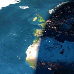
I got sent this by a friend - I thought I would share it as it is such a stunning photo:
This was taken by the crew on board the Columbia during its last mission.
This photo was taken via satellite, on a cloudless day.
The picture is of Europe and Africa when the sun is setting.
Half of the picture is in night. The bright dots you see are the cities' lights. The top part of Africa is the Sahara Desert.
Note how the lights are already on in Holland, Paris, and Barcelona, and how it's still daylight in London, Lisbon, and Madrid.
The sun is still shining on the Straight of Gibraltar, and the Mediterranean Sea is already in darkness.
In the middle of the Atlantic Ocean you can see the Azores Islands; below them to the right are the Madeira Islands; a bit below are the Canary Islands; and further south, close to the farthest western point of Africa, the Cape Verde Islands.
Note how the Sahara is huge and can be seen clearly both during daytime and nighttime.
To the left, on top, is Greenland, totally frozen.

")
 /www.snopes.com/photos/sunset.asp