Koglin
Fish Crazy
So I was going through some pics on the camera and came across a bunch of when my g/f and I went to Grand Lake (town name) for a few nights. This was in June 2020, before the fires. The area west and north of Grand Lake caught fire (known as the East Troublesome Fire).
For those few days, we hiked/kayaked around within 30 miles of the Granby lake area (directly behind Rocky Mountain National Parks west/southwest side). Hit a lot of trails, hopped a lot of islands. I think these pic's will help show how these fires spread so rapidly, considering the fuel + wind. Additionally, due to the mountainous region, fires cannot be fought on the slopes due to how rapidly wind up there can change directions, immediately endangering firefighters.
There is a widespread black beetle infestation throughout the region, and it has been decimating the forests (from what the locals told me during the trip). Remember, these pictures were taken throughout a 30-mile radius.
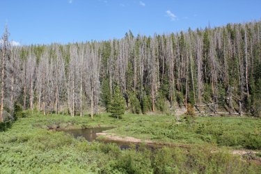
I want you to look closely at 2 things in these photos:
1. The percentage of dead trees you see mixed into the treetops on the background hills and mountains (courtesy of the beetles).
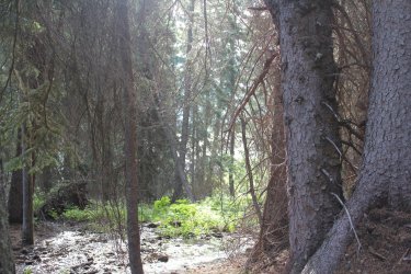
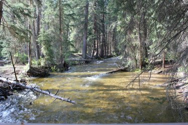
2. In the pictures that show it, look closely at the sheer amount of dead trees lay on the ground (also courtesy of beetles). Off the sides of the trails, there were piles of trees they had been pulling off the footpath over time. And I mean like, piles of 12-24 trees. We didn't take photos of the real thick of it (didn't think to at the time), but off the trails in the natural woods - it was unbelievable how many dead trees were on the ground laying all over EVERYTHING.
I think these will help to see how these fires spread so rapidly, considering the fuel + wind. Additionally, due to the mountainous region, fires cannot be fought on the slopes anymore due to how rapidly wind up there can change directions, immediately endangering firefighters.
*Note - this is not the fault of the Wildlife Management in Colorado - but that's a thread for a different time.


(Excuse my pandemic mullet in these next few, everything had been closed for months)
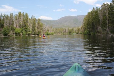
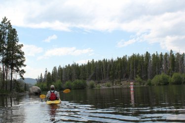
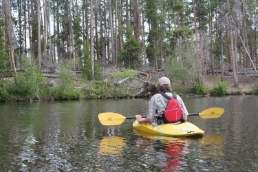
In these 3, those are islands on either side of us, which also got hit by the beetles. In the 2nd one, there is actually a deer on the island in front of me - dunno how he made it out there (can see his rump). In the 3rd one, zoom in on the mountains in front of me and check out the number of dead trees - those exact mountains are on the southern edge of Rocky Mountain National Park


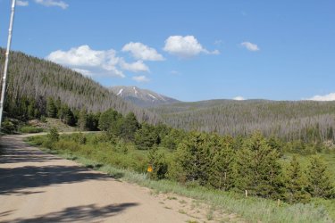
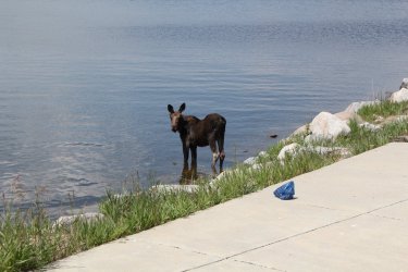
AND now, for the Contrast. In this last picture, look closely at the forests. This area is roughly 5 miles directly south of where we were kayaking and has not been hit by the beetle infestation yet. Crazy difference between where beetles have hit - right?

*Edit - I wanted to point out, normally I would run these through photoshop to improve the viewing quality a bit, but since I just came across them on the camera I didn't take the time to. Sometime (maybe) I'll show some actual adventure photos if they become relevant to something on the forum.
For those few days, we hiked/kayaked around within 30 miles of the Granby lake area (directly behind Rocky Mountain National Parks west/southwest side). Hit a lot of trails, hopped a lot of islands. I think these pic's will help show how these fires spread so rapidly, considering the fuel + wind. Additionally, due to the mountainous region, fires cannot be fought on the slopes due to how rapidly wind up there can change directions, immediately endangering firefighters.
There is a widespread black beetle infestation throughout the region, and it has been decimating the forests (from what the locals told me during the trip). Remember, these pictures were taken throughout a 30-mile radius.
I want you to look closely at 2 things in these photos:
1. The percentage of dead trees you see mixed into the treetops on the background hills and mountains (courtesy of the beetles).
2. In the pictures that show it, look closely at the sheer amount of dead trees lay on the ground (also courtesy of beetles). Off the sides of the trails, there were piles of trees they had been pulling off the footpath over time. And I mean like, piles of 12-24 trees. We didn't take photos of the real thick of it (didn't think to at the time), but off the trails in the natural woods - it was unbelievable how many dead trees were on the ground laying all over EVERYTHING.
I think these will help to see how these fires spread so rapidly, considering the fuel + wind. Additionally, due to the mountainous region, fires cannot be fought on the slopes anymore due to how rapidly wind up there can change directions, immediately endangering firefighters.
*Note - this is not the fault of the Wildlife Management in Colorado - but that's a thread for a different time.
(Excuse my pandemic mullet in these next few, everything had been closed for months)
In these 3, those are islands on either side of us, which also got hit by the beetles. In the 2nd one, there is actually a deer on the island in front of me - dunno how he made it out there (can see his rump). In the 3rd one, zoom in on the mountains in front of me and check out the number of dead trees - those exact mountains are on the southern edge of Rocky Mountain National Park
AND now, for the Contrast. In this last picture, look closely at the forests. This area is roughly 5 miles directly south of where we were kayaking and has not been hit by the beetle infestation yet. Crazy difference between where beetles have hit - right?
*Edit - I wanted to point out, normally I would run these through photoshop to improve the viewing quality a bit, but since I just came across them on the camera I didn't take the time to. Sometime (maybe) I'll show some actual adventure photos if they become relevant to something on the forum.
Attachments
Last edited:

